Year in Review: SpaceWill's Selected Images on 12 Global Eve
Source:SpaceWill Date:2022-01-04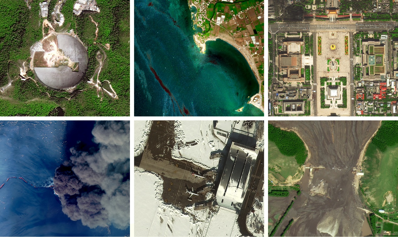
The busy 2021 has passed in a blink of an eye. We are so lucky to have you as our most loyal and supportive customers, clients and partners. As a satellite imagery supplier, our “eyes” (SuperView, GF and ZY satellites) in the space captured many globally concerned events during the year. Below are the images we selected on 12 global events:
1.
Cleanup of Arecibo Observatory Telescope, Puerto Rico

Last December 1, Arecibo Observatory Telescope’s central platform collapsed into the dish. It used to be the world’s largest single-unit radio telescope for 53 years until FAST in China began observations in 2016. GF-2 satellite image collected on March 13, 2021 showed the cleanup of iconic Arecibo Observatory. The cleaning up could cost 30-50 million USD according to the National Science Foundation, USA.
2.
The Even Given Ship Blocked Suez Canal, Egypt

In March 2021, Suez Canal was blocked for six days after the grounding of Ever Given, a 20,000 TEU container ship. This 400-metre-long vessel was buffeted by strong winds in the morning of 23 March, and ended up wedged across the waterway with its bow and stern stuck in the canal banks, blocking all traffic until it was freed. The above SuperView-2 image showed the tugboats positioned alongside the Ever Given, and dredging operations are in progress to remove sand from around the ship.
3.
China Taiwan’s Sun Moon Lake Shrunk Dramatically due to Drought
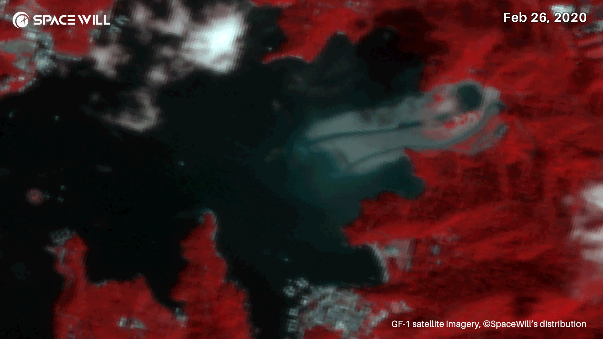
In April 2021, China Taiwan was affected by the worst drought in 56-year record. It turned Sun Moon Lake into barren moonscape. The Lake is one of the most amazing natural landmarks in Taiwan province. It is reported that the water level fell from normal depth 27m to 14m in the month. The before-and-after GF-1 satellite images in false color revealed the Lake dramatically shrunk, especially of east side.
4.
Torrential Rains Destroyed Two Dams in Inner Mongolia, China


On July 18, Xinfa and Yong’an dams in North China's Inner Mongolia collapsed after heavy torrential rains. The SuperView-1 images on DEC 8, 2020 and July 21, 2021, showed the dams were badly damaged, especially that Xinfa Dam was totally shattered by the floods, large-area farmland was submerged.
5.
Summer Rainstorms Caused Severe Flooding in Central China

Throughout the whole July, China's He’nan province was affected by severe flooding. Record-breaking figures were observed in 19 weather stations in the province, and on July 20, Zhengzhou, the provincial capital, recorded 201.9 mm of rainfall within an hour, the highest ever figure recorded since measurements began in 1951. SuperView-1 images taken of Zhengzhou before & after the rainfalls and flooding to the area along Jialu River, showed massive farmlands soaked in the water and the river much broader than normal.
6.
Forest Fire in Akkar Governorate, Lebanon

On July 28, a huge wild fire burst into the forest in Akkar Governorate, Lebanon. SuperView-1 satellite collected the image of the burnt scar on August 1, 2021. Compared this image with the one collected on September 6, 2019, it was calculated that the fire burned over 15 square km of the forest.
7.
Earthquake Struck Pic Macaya National Park, Haiti

On August 14, a magnitude 7.2 earthquake struck southwestern Haidi. The quake triggered massive landslides and resulted in a large number of deaths. GF-2 satellite imagery collected on August 19 revealed one of the landsides appeared in Pic Macaya National Park in Haiti.
8.
Oil Pollution in Mediterranean Sea Nearby Baniyas Oil Refinery, Syria

On August 23, a leak occurred from one of the fuel tanks at the Baniyas Oil Refinery that is Syria’s largest Refinery. The oil spread along the coast of the Mediterranean countries and caused massive pollution. SuperView-1 image on August 29 showed the oil trail moving with sea waves and a ship working to clean the oil on the sea.
9.
National Day Celebration on Tiananmen Square, Beijing, China
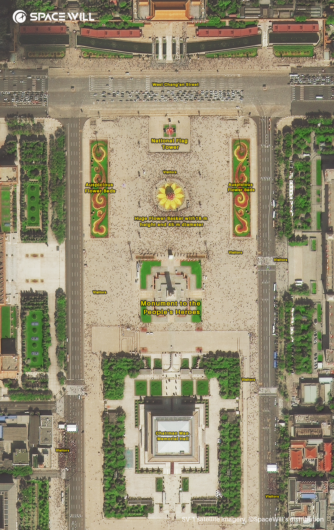
On October 1, thousands of citizens and travelers from all over China strolled leisurely on Tiananmen Square that is the largest square in the world. For memorial and celebration, Tiananmen Square is decorated with beautiful and fresh flowers during September and October every year. Collected in the late morning October 1, the SuperView-1 satellite image showed the grand buildings, beautiful flower beds, people mountain and people sea strolling around on the Square.
10.
Eruption of Cumbre Vieja volcano on La Palma Island, Spain

On September 19, Cumbre Vieja Volcano erupted and caused the evacuation of around 7,000 people. The lava flow covered over 1,000 hectares, destroyed over 3,000 buildings, cut the coastal highway and formed a new peninsula finally. SuperView-1 satellite imaged the Lava flow into the sea and heavy smoke on Oct 7, 2021. The image showed a shocking view of the eruption, ash plume and lava flow.
11.
Heavy Snowstorm Blanketed East of Inner Mongolia, China

From November 5 to 10, heavy snowstorm continually struck Tongliao city in north China’s Inner Mongolia. It blocked citizens travel and even brought some areas to a standstill. SpaceWill deployed SuperView-1 satellite to observe the disastrous areas. The image showed the cleaned Tongliao Airport’s runaway end where there were two parking airplanes.
12.
Mayfield County, Kentucky, USA

On December 10, a violent, long-tracked tornado moved across Western Kentucky, producing catastrophic damage in Mayfield and several other towns. Before-and-after images captured by SuperView-1 on January 3, 2021 and GF-7 December 15, 2021 satellites revealed how badly Mayfield, Kentucky, USA was struck. On the new image collected by GF-7, it revealed the debris and structural damage massively in the county.
CONTACT US
L5, Bld. B, Yicheng Center, Haidian District
Beijing, China 100089
marketing@spacewillinfo.com
Office: +86-10-58818811 ext.840
Cell: +86 138 1008 1424